A single thread to the outside world
Most airports are connected to dozens of destinations. Even a modest regional hub will have multiple airlines, multiple directions, a fallback if a carrier suspends service. For the places on this list, none of that applies. Each has a single commercial air route, one airline, one destination, one thread connecting it to the rest of the world. Snap that thread, and the only option is a ship, a government evacuation flight, or waiting.
What distinguishes these airports from simply "remote" destinations is their total dependency. Easter Island has LATAM. St. Helena has Airlink. Niue has Air New Zealand. Remove any one of those airlines from the schedule, and the community loses its only air connection to the world. For some of these islands, "the flight" isn't a travel convenience, it is the supply chain, the medical evacuation route, and the economic lifeline, all in one.
This list focuses on places served by genuine scheduled commercial aviation with a single air route to a single external destination. Destinations where multiple domestic internal connections or military-only services exist are not considered. Ranked loosely by degree of geographic isolation, these are the ten places where one flight is truly all there is.
The 10 most isolated single-route airports
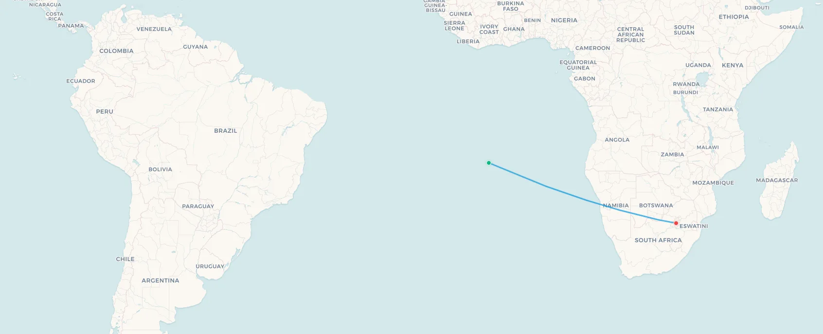
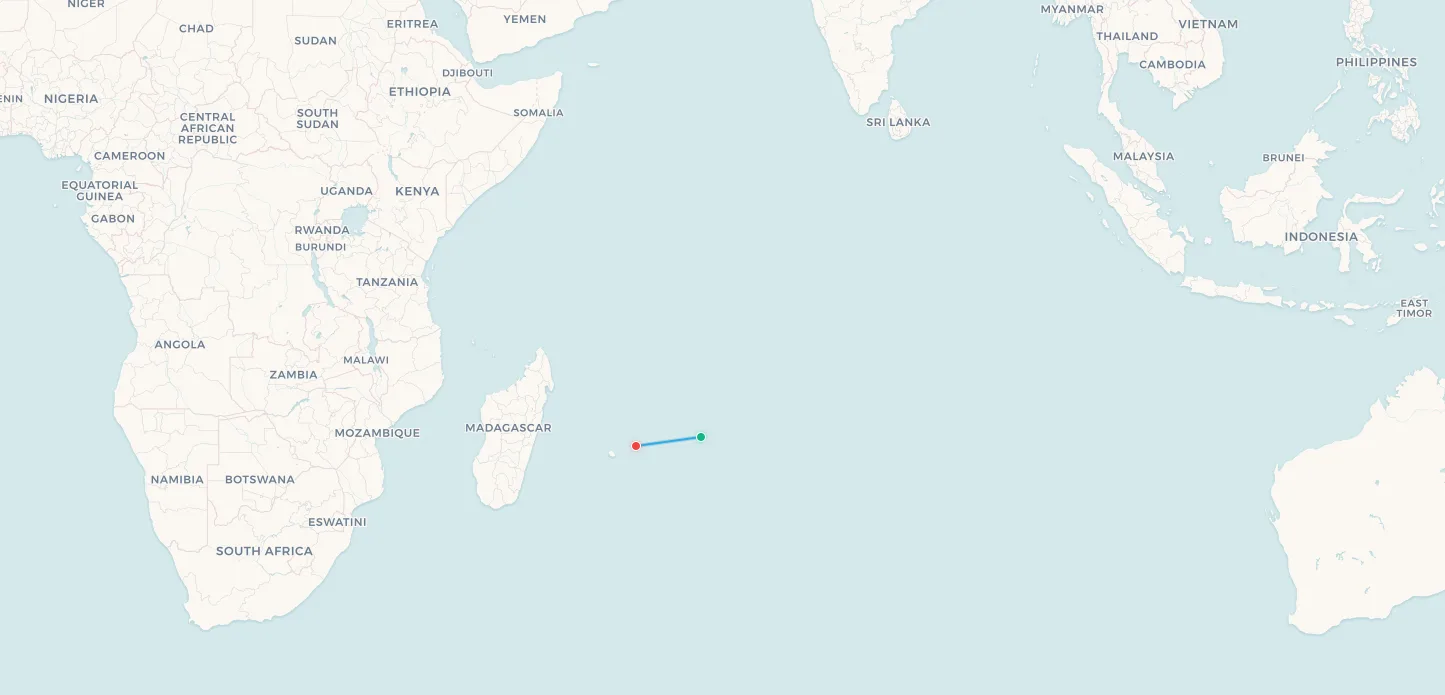
1. St. Helena Island (HLE) → Johannesburg, South Africa (JNB)
Airline: Airlink
Aircraft: Embraer E190
Distance: ~2,800 km (1,740 miles)
Flight Time: ~6 hours
Frequency: 2× weekly
Population: ~4,500
No airport in the world has a more improbable origin story than St Helena Airport. Opened in 2016 after four decades of planning, construction and controversy, its final bill ran to approximately £285 million, equivalent to around £63,000 per island resident, it was meant to end the island's status as one of the last places on Earth accessible only by sea. It nearly didn't. The inaugural commercial service, operated by a Comair Boeing 737 from Johannesburg in April 2016, had to divert to Namibia after pilots encountered severe wind shear on approach. The route was suspended before it properly began.
The culprit was the island's geography: St Helena sits in the South Atlantic 1,950 km from the coast of southern Africa, rising steeply from the ocean to an 818-metre central peak. Trade winds accelerate and distort unpredictably when they hit the escarpment near the airport, creating approach conditions that defeated the 737. Airlink eventually took over the route with smaller Embraer E190 aircraft, which proved better suited to the conditions. Today the island receives approximately two flights per week from OR Tambo International in Johannesburg, and that is the totality of St Helena's commercial air connectivity.
Before the airport, the island was served exclusively by the RMS St Helena, a Royal Mail Ship running from Cape Town on a journey of five or more days. The ship was retired in 2018. Napoleon Bonaparte spent his final six years of exile on St Helena, dying here in 1821; the island has been a British Overseas Territory since 1834. For the 4,500 Saints, as islanders call themselves, Airlink's twice-weekly Embraer represents a connection to the world that their ancestors could only have dreamed of, and a fragility they cannot afford to ignore.
📥 Download route data (CSV) | 🗺️ Track this route in the app
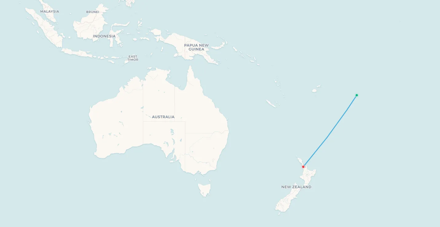
Search flights Longwood → Johannesburg Search flights HLE → JNB2. Niue (IUE) → Auckland, New Zealand (AKL)
Airline: Air New Zealand
Aircraft: Airbus A320
Distance: ~2,400 km (1,490 miles)
Flight Time: ~3 hours
Frequency: 2× weekly
Population: ~1,600
Niue is perhaps the starkest example of aviation dependency anywhere on this list. Air New Zealand operates an Airbus A320 from Auckland twice per week, that is the complete scheduled air service for an entire nation. Not a region, not an island territory. A sovereign self-governing state in free association with New Zealand, a member of the Pacific Community, a country with its own government, police force and foreign affairs office. Two weekly narrowbody services.
The island is a raised coral atoll, one of the largest in the world, sitting just west of the International Date Line some 2,400 km northeast of New Zealand. Its population of approximately 1,600 is declining: about ten times as many Niueans live in New Zealand as on the island itself, a consequence of free movement rights granted under the association agreement. Tourism, powered almost entirely by those twice-weekly Air New Zealand services, is the island's primary economic activity. With only two weekly services, most Niue stays are built around the schedule: four days or two weeks are not natural options. Missing a flight is not a minor inconvenience; the next service is only a few days away, but accommodation and plans must extend accordingly.
Havelock Airport's single runway sits atop the coral plateau, with the ocean visible from both ends of the strip. Landings on gusty days give passengers a memorable introduction to the island, and departures require a sharp climb to clear the plateau edge. For aviation enthusiasts, the sight of an Airbus A320 deploying on a thin strip of Pacific coral for a twice-weekly service to a nation of 1,600 people is one of those genuinely strange spectacles that commercial aviation occasionally produces.
📥 Download route data (CSV) | 🗺️ Track this route in the app
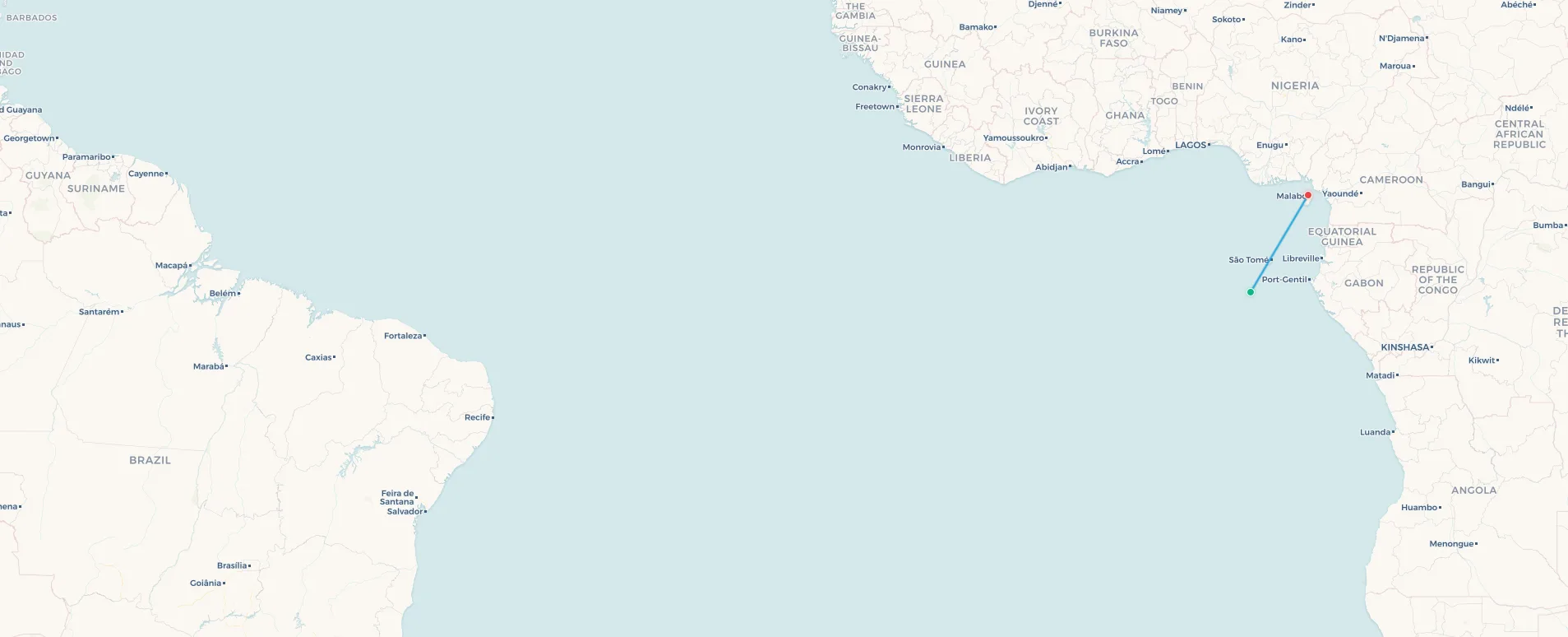
Search flights Alofi → Auckland Search flights IUE → AKL3. Annobón Island (NBN) → Malabo, Equatorial Guinea (SSG)
Airline: CEIBA Intercontinental
Aircraft: ATR 42
Distance: ~650 km (404 miles)
Flight Time: ~2 hours
Frequency: 1× weekly
Population: ~5,000
Annobón Island is one of the least-known islands in Africa, a small volcanic outcrop in the Gulf of Guinea located some 350 km southwest of São Tomé and roughly 650 km from Bioko Island, home to Malabo, the capital of Equatorial Guinea. Named by Portuguese sailors who discovered it on New Year's Day 1470, anno bom meaning "good year" in Portuguese, the island was traded from Portugal to Spain in 1778 and became part of Equatorial Guinea at independence in 1968. Its approximately 5,000 inhabitants speak Annobonese, a Portuguese-based creole, making the island linguistically distinct from Spanish-dominant Equatorial Guinea and entirely unlike its neighbours.
CEIBA Intercontinental, Equatorial Guinea's national airline, operates the island's sole commercial air link: a weekly ATR 42 service to Malabo. There is no other scheduled carrier, no route to neighbouring São Tomé just 350 km away, no connection to Gabon, Cameroon, or any other continental point. Everything other than what can be caught from the sea or grown on the island's fertile volcanic slopes depends on that single weekly flight, or on the occasional supply vessel. Medical emergencies requiring hospital care mean a transfer to Malabo on the next available service.
Annobón Airport (NBN) was inaugurated in 2010, ending a period of complete dependence on sea transport. Before the airport, reaching Malabo typically required a multi-day voyage. The new facility brought the island into scheduled commercial aviation for the first time, yet the connection remains thin: one flight per week is, in practical terms, only marginally better than a ship if something goes wrong between services. For the island's residents, CEIBA's ATR 42 is the link, and a fragile one at that.
📥 Download route data (CSV) | 🗺️ Track this route in the app
Search flights San Antonio de Pale → Malabo Search flights NBN → SSG4. Funafuti, Tuvalu (FUN) → Nadi, Fiji (NAN)
Airline: Fiji Airways
Aircraft: ATR 72-600
Distance: ~1,095 km (680 miles)
Flight Time: ~2 hours
Frequency: ~3× weekly
Population: ~11,300
Tuvalu is a country that may not exist by the end of this century. Composed of nine coral atolls scattered across the central Pacific, the nation averages just 2.5 metres above sea level. Climate scientists project that the combination of sea level rise and intensifying cyclone activity will render the atolls uninhabitable within decades, potentially making Tuvalu the first country in human history to be physically erased by climate change. Its government has already signed agreements allowing citizens to relocate to Australia and has purchased land in Fiji as a form of floating sovereignty, the right to claim statehood even without territory.
For now, Tuvalu exists, and Funafuti International Airport is its connection to the world. Fiji Airways operates ATR 72-600 turboprop flights to Nadi approximately three times per week; a second service to Suva was inaugurated in August 2025, giving Tuvalu its first multi-destination air connectivity, though the addition of a second Fijian destination barely diminishes the fragility of an air network that still depends entirely on a single carrier. The airport runway itself poses an engineering curiosity: at a maximum elevation of 3 metres, parts of it flood during king tides, and the terminal has been progressively modified to cope with periodic inundation. Annual passenger numbers are in the low thousands, making this one of the least-trafficked international airports on Earth that is still genuinely operational.
From Nadi, passengers can connect onward to Auckland, Sydney, Tokyo, or Los Angeles. From Funafuti, there is only Nadi. The implications for any Tuvaluan requiring urgent medical attention, a cardiac event, a serious trauma, are significant: the nearest advanced hospital is an ATR 72 ride and a bus journey away, assuming a service is available that day.

📥 Download route data (CSV) | 🗺️ Track this route in the app
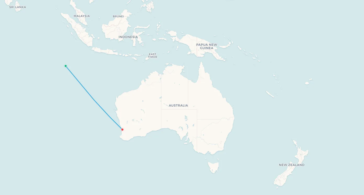
Search flights Funafuti → Nandi Search flights FUN → NAN5. Cocos (Keeling) Islands (CCK) → Perth, Australia (PER)
Airline: Qantas (QantasLink)
Aircraft: Boeing 737-800
Distance: ~2,750 km (1,710 miles)
Flight Time: ~3.5 hours
Frequency: ~3× weekly
Population: ~600
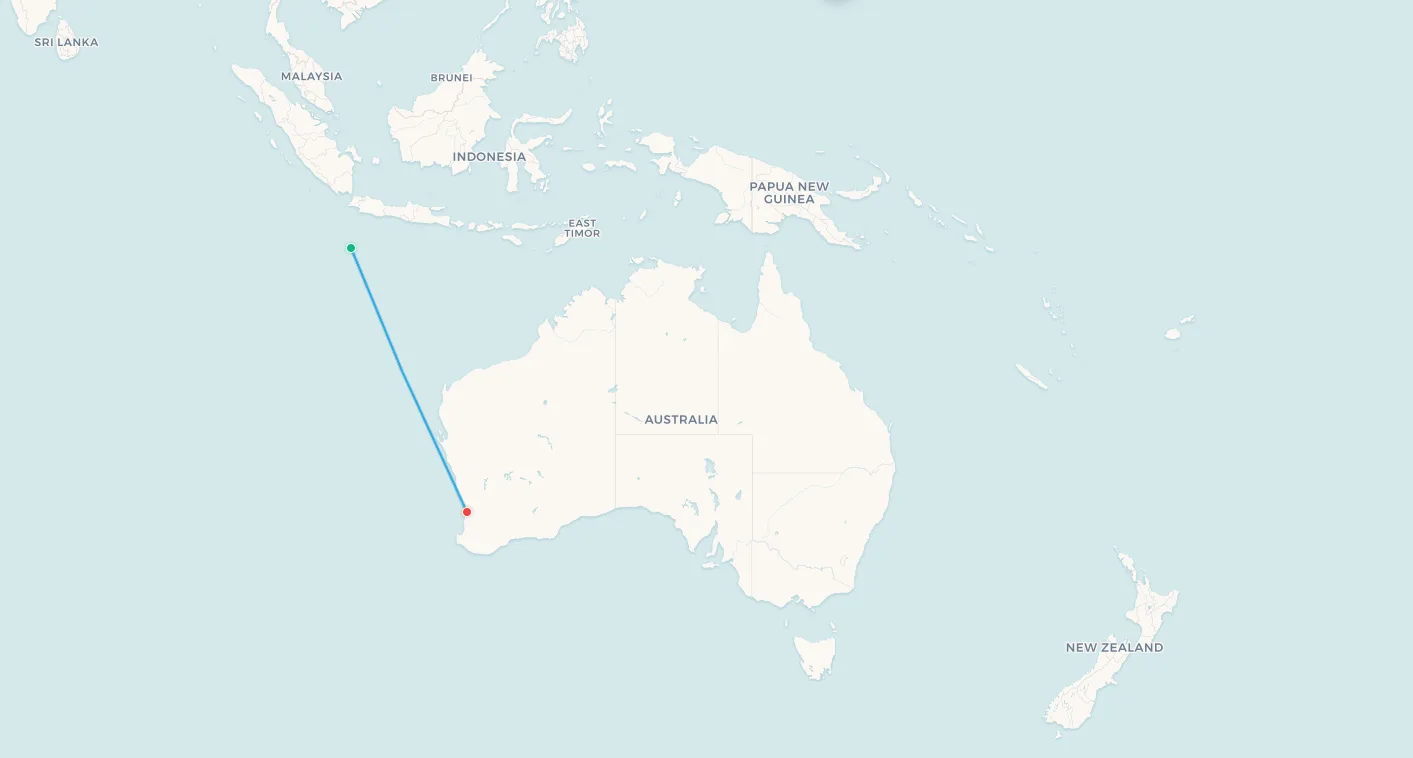
The Cocos (Keeling) Islands are an Australian external territory of 27 small coral islands in the eastern Indian Ocean, roughly equidistant between Western Australia and Sri Lanka. With a total population of around 600 people split between Home Island, inhabited largely by the Cocos Malay community, whose ancestors were brought to work the coconut plantations in the 1820s, and West Island, home to the administrative centre and the airport, it is one of the smallest and most remote inhabited territories in the world.
QantasLink operates the sole air connection: a Boeing 737-800 service from Perth three times per week. There is no other carrier, no connecting service to Asia or the Middle East, and no inter-territory hop to Christmas Island further to the northeast. Everything that arrives on the islands, food, medicine, spare parts, tourists, comes through Perth by air or by the occasional supply ship. The islands' most famous historical footnote is the 1914 Battle of Cocos, in which the German cruiser SMS Emden was intercepted and sunk by HMAS Sydney after attacking the islands' cable relay station. That station was a critical node in imperial communications, and the islands' very remoteness made them strategically vital. Today, their remoteness makes them a diving and nature tourism destination operating on one thin air bridge to the Australian mainland.
📥 Download route data (CSV) | 🗺️ Track this route in the app
Search flights Cocos Keeling Island → Perth Search flights CCK → PER6. Christmas Island (XCH) → Perth, Australia (PER)
Airline: Qantas (QantasLink)
Aircraft: Boeing 737-800
Distance: ~2,600 km (1,615 miles)
Flight Time: ~3.5 hours
Frequency: ~2× weekly
Population: ~2,000
Christmas Island sits 360 km south of Java in the Indian Ocean and shares its territorial administrator, Australia, with Cocos Keeling. It also shares its air carrier: QantasLink and Virgin Australia Regional Airlines both operate 737-800 services on the Perth route, the only commercial route connecting the island to the outside world. The population of approximately 2,000 is predominantly of Chinese and Malay descent, a legacy of phosphate mining operations that began in the late 19th century and continue today alongside tourism and the public sector.
The island is globally celebrated among naturalists for the annual Christmas Island red crab migration, in which an estimated 120 million crabs descend from the rainforest interior to breed at the ocean's edge, temporarily closing roads and overwhelming the landscape in a moving tide of red. The island's biodiversity, 63% of its land area is a national park, hosting species found nowhere else on Earth, makes it a specialist destination for ecotourists who accept the twice-weekly flight schedule as part of the adventure. The airport's clifftop location means approaches over open ocean, with dense endemic rainforest visible on one side and the Indian Ocean on the other.
For the QantasLink 737 that connects Christmas Island to Perth, the route carries a broad cross-section of modernity meeting isolation: nature tourists in one seat, government contractors in the next. Whatever the purpose of travel, the flight is the only option, and cancellations due to weather or mechanical issues on an aircraft 2,600 km from its maintenance base are not abstract risks on a route like this.
📥 Download route data (CSV) | 🗺️ Track this route in the app
Search flights Christmas Island → Perth Search flights XCH → PER7. Saba (SAB) → Sint Maarten (SXM)
Airline: Winair
Aircraft: DHC-6 Twin Otter
Distance: ~50 km (31 miles)
Flight Time: ~15 minutes
Frequency: Multiple daily
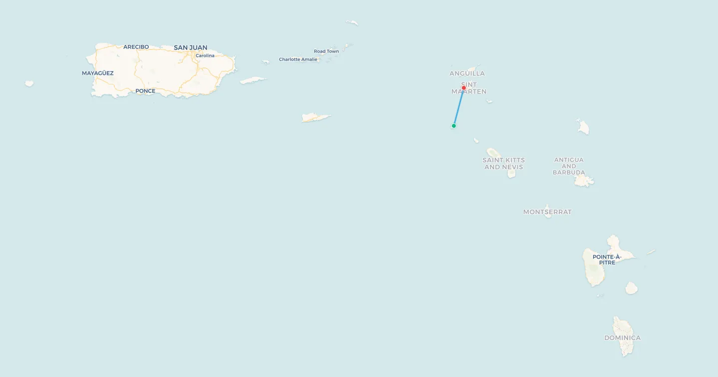
Population: ~2,200
Saba is the definition of an island that aviation should not be able to serve. A single extinct volcanic cone rising sharply from the Caribbean Sea, it has no beaches, no natural harbour capable of handling regular traffic in rough weather, and until 1963 no airport at all. What it does have, carved into the plateau at the island's base, is Juancho E. Yrausquin Airport: at 400 metres, officially the world's shortest commercial runway. To put that in context, the landing roll alone for a Boeing 737 on arrival at a normal airport uses more asphalt than Saba's entire strip. Both ends of the runway drop directly into the sea. Every aircraft that uses it must stop before it does.
Winair, the Windward Islands Airways based in Sint Maarten, operates daily Twin Otter services between SAB and Princess Juliana International Airport. The flight covers roughly 50 km and takes about 15 minutes. On approach, the pilot descends steeply toward the cliff edge, the ocean immediately below the aircraft's nose. On departure, the climb-out over the ridge happens fast. The DHC-6 Twin Otter, with its short-field performance and robust construction, is one of the very few production aircraft that can operate this route at all. No jet serves Saba. No jet can.
Without Winair's Twin Otter, reaching Saba from Sint Maarten requires a two-hour ferry in conditions that are frequently uncomfortable and sometimes impossible. For the island's 2,200 residents, a special municipality of the Kingdom of the Netherlands, the fifteen-minute flight is not merely convenient, it is essential. Saba has a small medical facility but no hospital; anything beyond basic care requires evacuation by the same Twin Otter to Sint Maarten's medical facilities. For a runway that barely exists, it carries an outsized burden.
📥 Download route data (CSV) | 🗺️ Track this route in the app
Search flights Saba → Philipsburg Search flights SAB → SXM8. Easter Island (IPC) → Santiago, Chile (SCL)
Airline: LATAM Airlines
Aircraft: Boeing 787-9 Dreamliner
Distance: ~3,780 km (2,348 miles)
Flight Time: ~5.5 hours
Frequency: ~7× weekly
Population: ~8,000
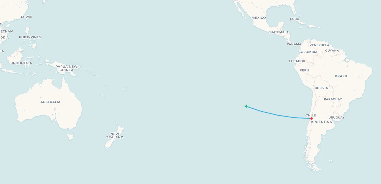
Easter Island, Rapa Nui in the language of its indigenous Polynesian inhabitants, is frequently cited as the most remote inhabited island in the world in terms of ocean distance to the nearest inhabited land. The next closest landmass with a permanent population is Pitcairn Island, itself one of the most isolated communities on Earth, at approximately 2,100 km to the west. The nearest continental land, the Chilean coast, lies 3,780 km to the east. No place on this list more powerfully illustrates what it means to depend on a single air link.
LATAM Airlines operates daily Boeing 787-9 Dreamliner flights from Santiago's Arturo Merino Benítez Airport to Mataveri International Airport on Rapa Nui, and for much of the year this is the island's only commercial air connection. Air Tahiti Nui operates a seasonal service to Papeete during peak summer periods, but for the majority of the calendar year, if LATAM suspends service, for maintenance, disruption, or commercial reasons, Easter Island is effectively cut off. The island's population of approximately 8,000, roughly 60% of whom are indigenous Rapa Nui, depends on LATAM for tourism income, medical referrals, government supply chains, and the approximately 100,000 annual visitors who come to see the moai.
Mataveri Airport holds a curious distinction: its runway was extended in the 1980s under an agreement with NASA to serve as an emergency landing strip for the Space Shuttle, giving this remote Pacific island a runway long enough to land a spacecraft. The extension remains, and today it accommodates the Boeing 787-9 Dreamliner with room to spare. Ironically, the island with a Space Shuttle-grade runway still depends on a single widebody jet service to Chile for its only year-round connection to the world.
📥 Download route data (CSV) | 🗺️ Track this route in the app
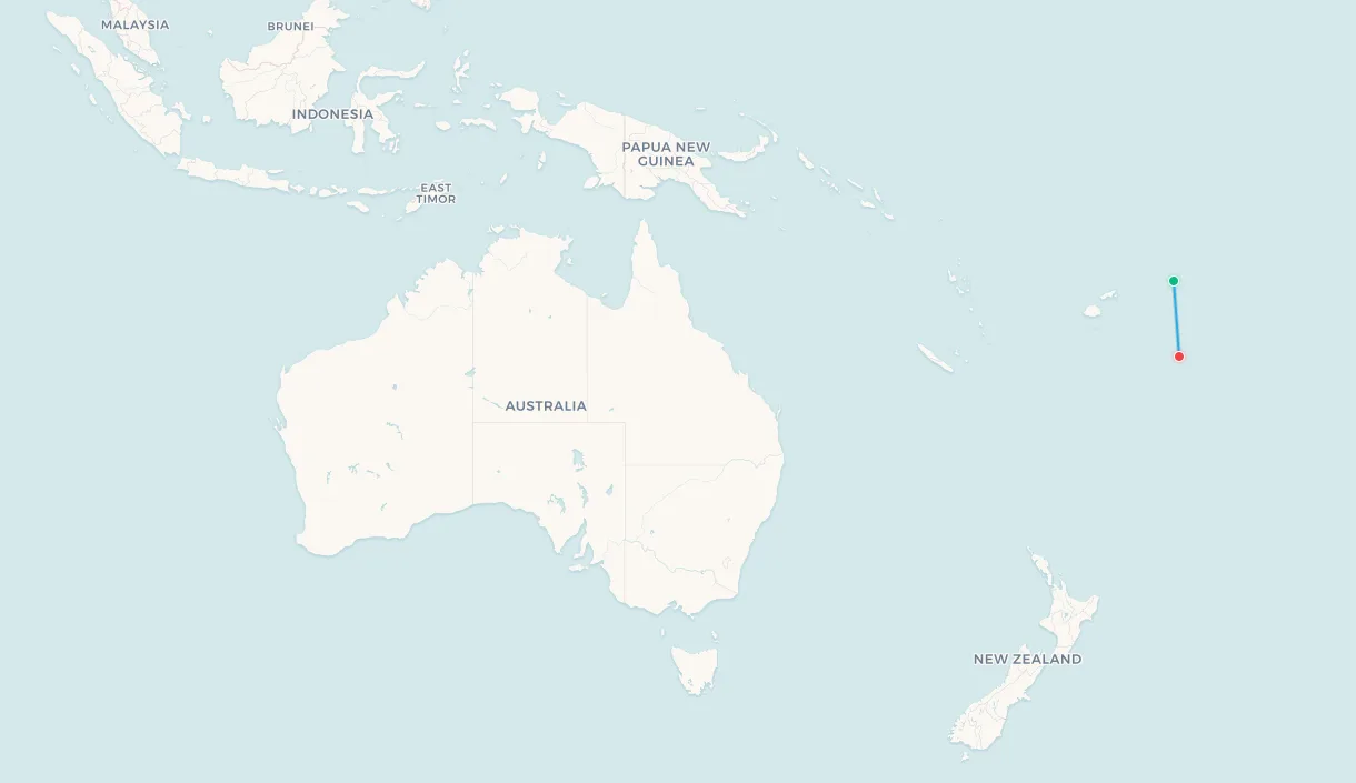
Search flights Easter Island → Santiago Search flights IPC → SCL9. Niuafoʻou, Tonga (NFO) → Nukuʻalofa (TBU)
Airline: Lulutai Airlines
Aircraft: DHC-6 Twin Otter
Distance: ~625 km (388 miles)
Flight Time: ~2 hours
Frequency: Weekly
Population: ~600
Niuafoʻou is Tonga's most remote inhabited island, located some 625 km north of Nukuʻalofa, far beyond the main Tongan island groups of Tongatapu, Ha'apai, and Vava'u. For most of oceanic history, its remoteness meant that ships passing nearby could not safely land: the island has no harbour and the surrounding reef made regular boat access nearly impossible in rough weather. The solution, for mail at least, was the tin can. For decades before any regular air service, sailors on passing vessels would throw sealed tin cans containing letters and packages into the ocean, and local swimmers would retrieve them. The practice earned Niuafoʻou its famous nickname: Tin Can Island.
Lulutai Airlines, Tonga's domestic carrier, operates Twin Otter service from Fua'amotu International Airport near Nukuʻalofa to Niuafoʻou Airport (NFO). The grass runway at 853 metres is just sufficient for the Twin Otter's short-field capabilities. The frequency is roughly weekly, making this one of the least-connected scheduled air services in the Pacific. The caldera lake visible on approach makes for a distinctive landing experience, but the practical reality is stark: when the weekly aircraft does not come, the island is as unreachable as it was in the days of tin cans. There is no backup flight, no alternative carrier.
Niuafoʻou's population of approximately 600 remains small partly by circumstance and partly because the island was evacuated twice during the twentieth century following volcanic eruptions, and many displaced residents never returned after resettlement on Tongatapu. Those who remain maintain a largely traditional way of life on an exceptionally isolated island, dependent on a single weekly turboprop and occasional supply vessels for any connection to wider Tongan society. The tin cans are long gone. The thread connecting Tin Can Island to the world has improved only slightly.
📥 Download route data (CSV) | 🗺️ Track this route in the app
Search flights Angaha, Niuafo'ou Island → Tongatapu Search flights NFO → TBU10. Rodrigues Island (RRG) → Mauritius (MRU)
Airline: Air Mauritius
Aircraft: ATR 72-500
Distance: ~574 km (357 miles)
Flight Time: ~1.5 hours
Frequency: Multiple daily
Population: ~42,000
Rodrigues is the outlier on this list. It is far better connected than any of the others in terms of flight frequency, Air Mauritius operates multiple ATR 72 services daily between Sir Gaëtan Duval Airport on Rodrigues and Sir Seewoosagur Ramgoolam International Airport on Mauritius, but it belongs here for a different reason: despite that frequency, every single one of those flights goes to exactly one place. There is no direct service to Réunion (just 650 km away), no connection to Madagascar, no routes to India, no code-share path anywhere except through Mauritius. An island of 42,000 people has as many daily departures as many regional European airports, yet all of them land at the same destination.
Rodrigues lies 574 km east of Mauritius in the Indian Ocean and is an autonomous region of Mauritius, with its own elected Regional Assembly and its own government. Virtually all imports arrive via Mauritius: electronics, pharmaceutical supplies, construction materials, consumer goods, all routed through a single hub 574 km to the west. Any Rodriguan requiring international travel must first fly to Mauritius and transfer. In this sense, the island lives in a state of managed dependency: well-served by frequent air travel while simultaneously captive to a single transit point for any connection beyond the immediate horizon.
The island's lagoon, beaches, and relatively undeveloped character attract tourists seeking an alternative to the busier Mauritian mainland, and the reliable Air Mauritius ATR 72 has made it accessible. But Rodrigues sits at the end of a chain, and for every place on this list, the question beneath the schedules is the same: what happens when the one link breaks?
📥 Download route data (CSV) | 🗺️ Track this route in the app
Search flights Rodriguez Island → Plaisance Search flights RRG → MRUAll 10 routes on one map
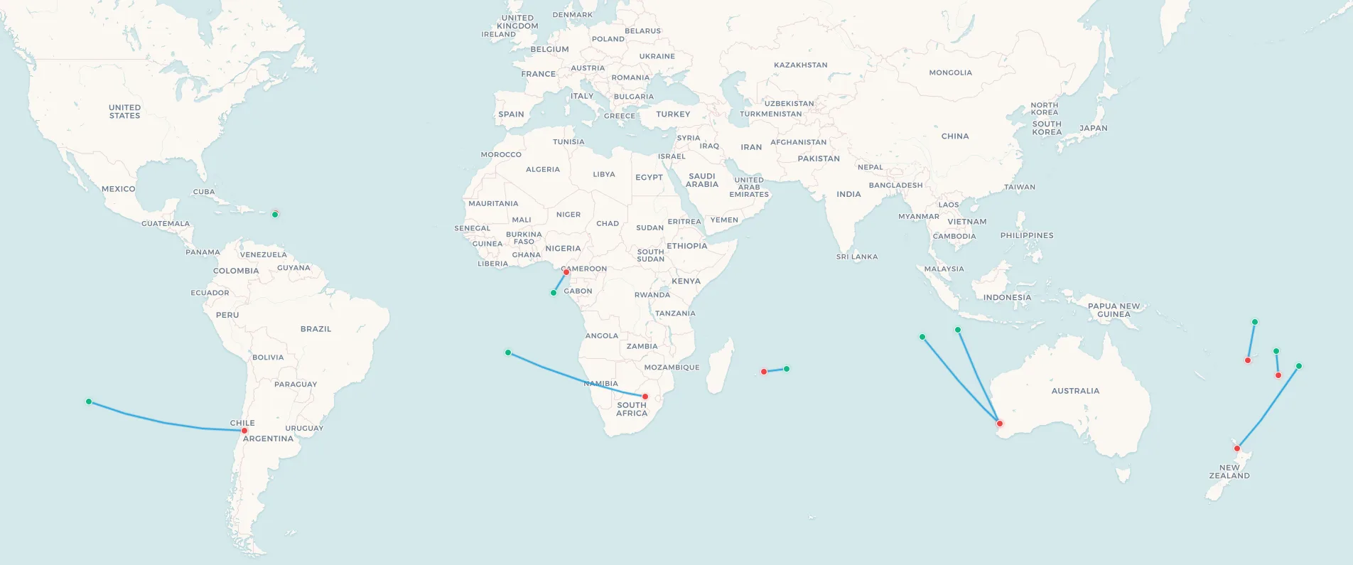
📥 Download all routes data (CSV) | 🗺️ Explore all routes in the app
What these places have in common
Strip away the geography and history, and a common profile emerges across all ten destinations:
- Island geography. All ten are islands or island groups. Islands are isolated by definition, and when population is small enough, they cannot sustain the traffic volumes needed to attract multiple competing carriers.
- Small populations. The largest, Rodrigues at 42,000, is an anomaly. The others range from 600 (Cocos Keeling) to 11,300 (Tuvalu). With annual passenger numbers in the low thousands, only one airline can operate economically on most of these routes, and sometimes only with some form of government support.
- Colonial or territorial connections. Many of these places are territories or dependencies of larger nations: St Helena (UK), Christmas Island and Cocos Keeling (Australia), Saba (Netherlands), Rodrigues (Mauritius). The single air link often maps directly to the political relationship: QantasLink from Perth serves both Australian Indian Ocean territories; Airlink from Johannesburg serves the British territory of St Helena.
- The route is the lifeline. On each of these islands, the flight is not just a travel option. It is the medical evacuation chain for anything beyond a local clinic. It is the supply chain for anything that cannot be grown or manufactured locally. Remove it permanently, and most of these communities could not sustain their current populations.
Honourable mentions: places no flight reaches at all
Some places are even more isolated than those on this list because they have no airport at all. Tristan da Cunha, in the South Atlantic roughly equidistant between South Africa and South America, is the most isolated permanently inhabited settlement in the world. With a population of approximately 250, it is accessible only by a roughly seven-day voyage from Cape Town aboard the RMS Edinburgh, which operates a handful of sailings per year. There is no airstrip, no helicopter pad, and no infrastructure plan to build one.
Pitcairn Island, famous as the refuge of the Bounty mutineers, has around 45 permanent residents and is accessible only by a supply vessel from New Zealand every few months. For these communities, the places on this list must look positively well-connected. The ten airports above, for all the thinness of their single-route air bridges, at least have one. That makes all the difference.
Track the world's most isolated routes
These ten air links represent some of the most unusual commercial flights operating today. Whether you are a flight completionist chasing obscure IATA codes, a geographer fascinated by island dependency economics, or simply curious about the fragile threads that tie some of the world's most extraordinary places to the rest of humanity, these routes are worth knowing about. Download the CSVs above to import any of them into your My Flight Routes map, or explore them directly in the app.