![The 5 Reasons a Flight Path Is Never a Straight Line [2026]](/blog/why-flights-dont-fly-in-a-straight-line/images/why-flights-dont-fly-in-a-straight-line.webp)
The Line You Draw Is Not the Line They Fly
Open any flight tracker mid-Atlantic and the shape on screen looks wrong. You booked Los Angeles to Dubai, and the aircraft is somewhere over Greenland. You booked New York to Hong Kong, and it is crossing the Arctic Ocean. Pull up the same pair on a paper map and the obvious route is a ruler-straight line that goes nowhere near the ice.
The aircraft is not lost, and it is not taking the scenic option. In almost every case it is flying the shortest possible path, and the flat map is the thing that is lying to you. That is the first of five reasons a real flight path bends, and the other four are wind, water, politics and rock. This guide works through all of them, with every route mapped, shareable and downloadable as a CSV you can drop straight onto your own map.
| What bends the route | How much it moves the line | Who decides |
|---|---|---|
| The curvature of the Earth | Hundreds or thousands of miles on long-haul | Geometry, nobody gets a vote |
| Wind and the jet stream | Typically 100 to 300 miles of lateral shift, and up to two hours of flight time | The airline's flight planning system, refreshed every few hours |
| Distance from a diversion airport | Constrains how far a track may wander over open ocean | The aircraft's ETOPS certification and the operator's approval |
| Closed or restricted airspace | One to four extra hours on the worst affected routes | Governments, regulators and insurers |
| Terrain and available airways | Detours of a few hundred miles around high ground | Terrain escape procedures and the published route structure |
Reason 1: The Earth Is a Sphere and Your Map Is Not
The shortest distance between two points on a sphere is not a straight line on a flat sheet of paper. It is a great circle: the arc you would trace by slicing the globe through both cities and its centre. Stretch a piece of string between two points on an actual globe and pull it taut, and the line it settles into is the great circle. Now peel that globe and flatten it, and the string bends.
The flattening is the problem. The Mercator projection, the one behind almost every map you have ever seen, was designed in 1569 so that a line of constant compass bearing appears straight. That is superb for a sailing ship and terrible for intuition, because it does it by stretching everything toward the poles. Greenland ends up looking the size of Africa. It is fourteen times smaller. Once high latitudes are inflated that badly, a route that passes through them has to look like a detour even when it is the direct path.
The effect is small on short hops and enormous on long ones. On a two-hour sector the great circle and the flat-map line are close enough that nobody notices. On a sixteen-hour sector the difference can be well over a thousand miles, which is why every route on the map below arcs toward a pole rather than running across the middle of the picture.
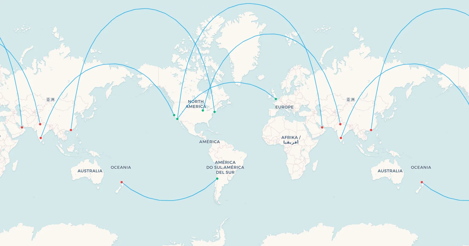
➕ Add these 6 routes to my map | 🗺️ Preview these routes on the map | 📥 CSV
Search flights Los Angeles → DubaiSearch flights LAX → DXBNotice the last route on that map. Santiago to Auckland bows south, toward Antarctica, for exactly the same reason the northern routes bow toward the Arctic. Great circles are not a northern-hemisphere quirk. They bend toward whichever pole is nearer, which is why the effect is invisible on routes that run along the equator and unmissable on routes that run across latitudes.
This is also the reason a surprising number of city pairs sit closer together than they look. When the shortest path runs over the top of the world, cities that appear to be on opposite sides of a map turn out to be within range of a single aircraft, which is how many of the most unlikely direct flights came to exist at all. The extreme version of the idea is a full transpolar flight route, where the great circle passes within a few degrees of the North Pole itself.
Reason 2: Over Water, What Matters Is How Far You Are From a Runway
Geometry gives you the shortest line. The next four reasons are about why an airline is not allowed, or not willing, to fly it.
The first constraint appears the moment a route leaves land. A twin-engined airliner may only operate a given distance from a suitable diversion airport, measured in flying time on one engine. That rule is ETOPS, an acronym that began life as Extended-range Twin-engine Operational Performance Standards and that pilots have translated for decades as "Engines Turn Or Passengers Swim". The FAA formally redefined it in 2007 to mean simply Extended Operations, and ICAO calls the wider concept EDTO, Extended Diversion Time Operations, both because the same logic now applies to aircraft with more than two engines.
The number attached to an ETOPS approval is that diversion time in minutes, and it has climbed steadily as engines have become more reliable.
| Approval | Maximum time from a diversion airport | What it unlocks |
|---|---|---|
| ETOPS-60 | 1 hour | The original 1953 limit, which kept twins off ocean crossings entirely |
| ETOPS-120 | 2 hours | The 1985 change that let twins cross the North Atlantic at all |
| ETOPS-180 | 3 hours | Covers the large majority of the world's water, and most long-haul flying today |
| ETOPS-330 | 5 hours 30 minutes | Boeing 787, enough for almost any South Pacific routing |
| ETOPS-370 | 6 hours 10 minutes | Airbus A350, the highest rating granted, and effectively unrestricted |
What this does to the drawn line is subtle but real. Over the North Atlantic the great circle and the ETOPS-legal corridor are close enough that they rarely fight, which is why the crossing looks so clean. Over the South Pacific they can diverge, because there is far more water and far less runway. The stepping stones matter enormously: Gander, Keflavik and Shannon in the north, and Honolulu, Christmas Island, Pago Pago and Nadi in the south, are airports that appear on an ETOPS chart long before they appear in anyone's travel plans.
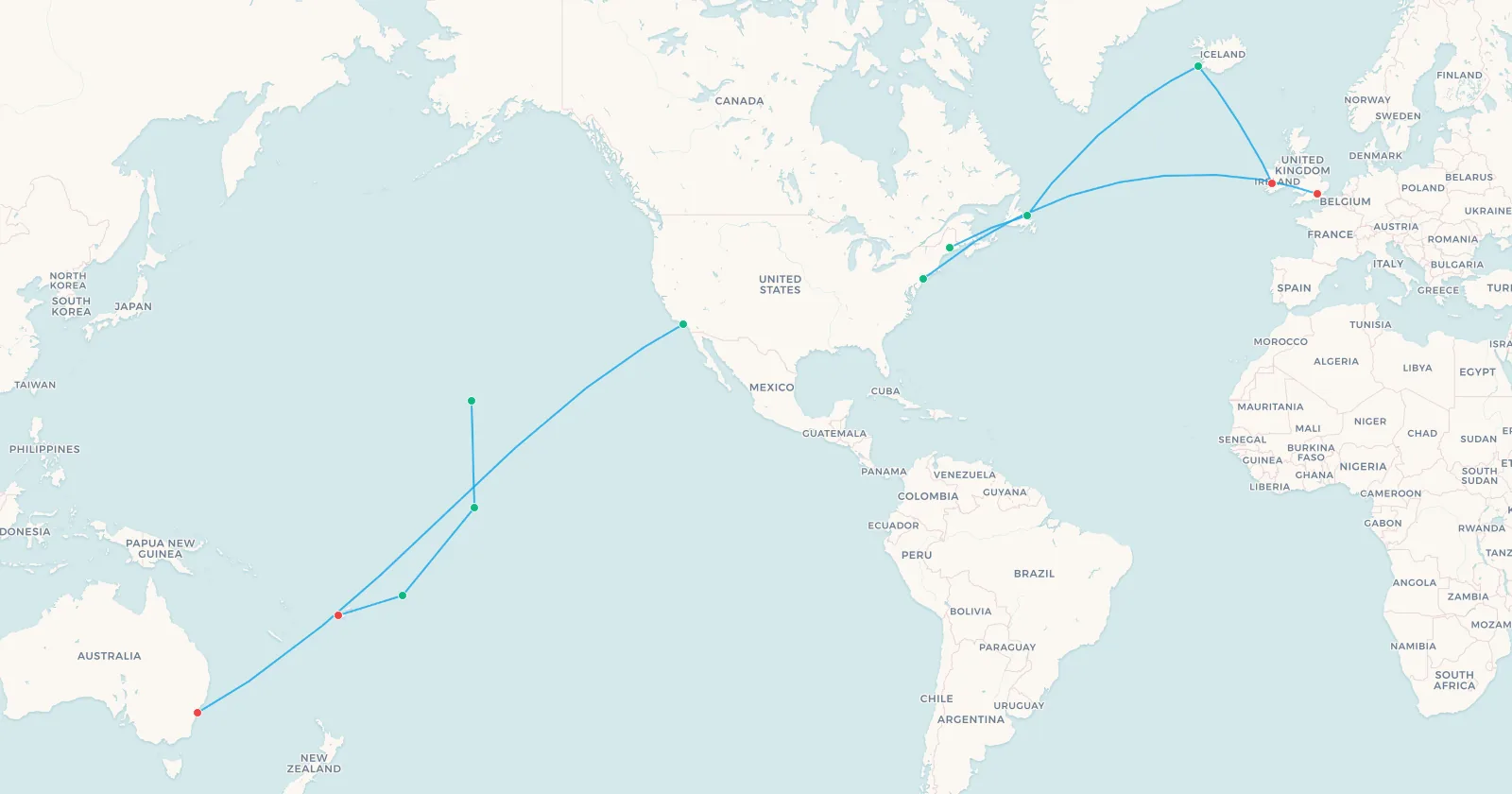
➕ Add these 8 routes to my map | 🗺️ Preview these routes on the map | 📥 CSV
Search flights New York → LondonSearch flights JFK → LHRThe North Atlantic adds a second layer on top of ETOPS. For decades the busiest ocean in aviation has been organised into the North Atlantic Organised Track System, a set of parallel tracks republished twice a day, eastbound overnight and westbound during the day, positioned to put the jet stream where it does the most good. Improved satellite surveillance has since made it possible to run days without a published track system at all, letting aircraft fly closer to their own optimum, but on a busy weather day the tracks still shape where every aircraft in the crossing ends up.
The other place this constraint bites is at the far end of the range envelope. Ultra-long routes over empty water spend hours with only a handful of usable alternates, which is part of what makes the world's longest flights so difficult to plan, and why the most isolated airports in the world punch so far above their traffic in operational terms.
Reason 3: The Wind Moves the Whole Sky
An aircraft does not fly through fixed space. It flies through air, and at cruise altitude that air is moving fast. Between roughly 30,000 and 40,000 feet, in a narrow band that snakes around the mid-latitudes, the jet stream blows west to east at 100 to 200 mph, and inside a concentrated core known as a jet streak it can exceed 250 mph.
That produces the single most obvious asymmetry in commercial aviation: the same city pair takes different times in each direction. Eastbound across the Atlantic or the Pacific, the aircraft rides the wind. Westbound, it fights it. Airlines do not simply accept the penalty, they route around it, which is why a westbound Pacific crossing often tracks noticeably further north than its eastbound counterpart on the same day.
The upper limit of what a tailwind can do was demonstrated on 9 February 2020. British Airways flight BA112, a Boeing 747-400, crossed from New York to London in 4 hours 56 minutes, the fastest subsonic transatlantic crossing on record and a mark since recognised by Guinness World Records. Storm Ciara had accelerated the polar jet into a streak with a tailwind touching 260 mph, and for about 24 minutes off Newfoundland the aircraft's ground speed reached 825 mph. The aircraft itself was flying at an ordinary 565 mph through the air. The rest was the sky moving underneath it.
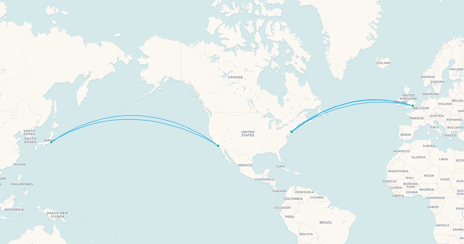
➕ Add these 5 routes to my map | 🗺️ Preview these routes on the map | 📥 CSV
Search flights Los Angeles → TokyoSearch flights LAX → NRTOne more thing decides the wind routing, and it is not physics. Airlines fly to a cost index, a number that tells the flight planning system how to trade fuel against time. A low cost index means fuel is the priority and the aircraft will accept a slower, wind-optimal track. A high one means the schedule matters more and the aircraft will burn extra fuel to get there. The route your aircraft flies today is the output of that calculation, run against a fresh forecast, usually within a few hours of departure.
Two consequences follow that passengers actually feel. Riding a jet stream can drop hours off a crossing, but it also means encountering the sheared edges of it, which is a large part of why some corridors dominate lists of the most turbulent flights. And because eastbound is the fast direction, it is also the direction that compresses a night into nothing, which is what makes eastbound crossings the worst routes for jet lag. For the record, the outright transatlantic record belongs to Concorde, at 2 hours 52 minutes, but that one was not riding anything.
Reason 4: Some Airspace Is Simply Shut
Geometry, water and wind are negotiable in the sense that they can be optimised. Closed airspace is not. When a country shuts its sky, the great circle through it stops existing as an option, and every route that used it gets redrawn.
The largest example in modern aviation is Russia. Before February 2022, more than 360,000 flights a year crossed Siberia, and that corridor was the whole reason Europe to Northeast Asia was as short as it was. The reciprocal bans that followed the invasion of Ukraine removed it for Western carriers overnight. European airlines now route southeast through Turkey and Central Asia, or north over the Arctic, adding roughly one to three hours depending on the pair.
No airline was hit harder than Finnair, whose entire Helsinki hub strategy was built on being the shortest way from Europe to Asia. Helsinki to Tokyo went from about nine hours to around thirteen. The geographic advantage did not shrink, it inverted, and the airline has spent years reshaping a network around the loss. Chinese carriers, meanwhile, kept their overflight rights, and now hold a structural cost advantage on exactly the routes their European competitors used to dominate.
Two more closures shape the 2026 map. Pakistan has barred Indian-registered aircraft from its airspace since 23 April 2025, with the restriction extended repeatedly through 2026; Air India has said the detours could cost it in the region of 600 million dollars over a year, and some Indian services to Central Asia have grown by three hours or more. And across the Middle East, the closures that began in February 2026 have at various points put Iranian, Iraqi, Syrian, Bahraini and Kuwaiti airspace off limits, with EASA advising operators to avoid a swathe of the region. Europe to Asia traffic has been squeezed onto two surviving corridors, one south via Egypt, Saudi Arabia and Oman, one north via the Caucasus.
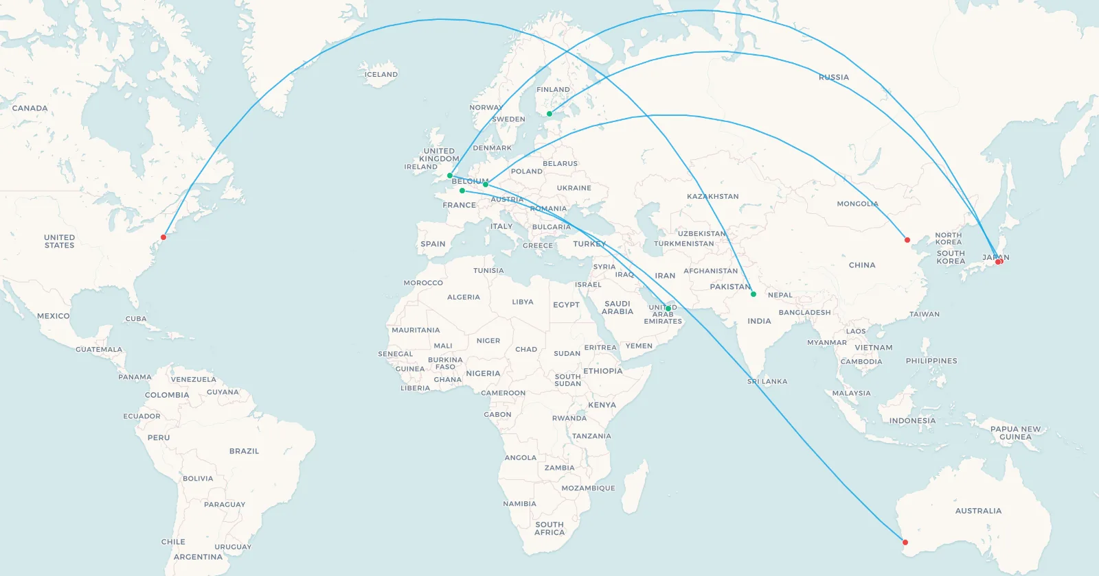
➕ Add these 6 routes to my map | 🗺️ Preview these routes on the map | 📥 CSV
Search flights Helsinki → TokyoSearch flights HEL → NRTClosures do not only lengthen routes, they delete them. Lufthansa dropped Frankfurt to Beijing outright on 26 October 2024, saying the detour around Russia had left it uncompetitive against the Chinese carriers that still had the shortcut, and British Airways suspended London to Beijing the same month. Air India withdrew its San Francisco nonstops from Bengaluru and Mumbai on 1 March 2026, because the Pakistan closure had stretched them to the point of needing a refuelling stop, taking one of the most northerly polar routings in the schedules with it. And Qantas launched a nonstop Paris to Perth service on 12 July 2024 that briefly made Charles de Gaulle one of the very few airports with direct flights to every continent, until the March 2026 Middle East closures forced it onto a Singapore routing. The knock-on effects on the Europe to Australia market, and the alternatives that have emerged, are covered in detail in our guide to alternative Australia to Europe routes.
Reason 5: Terrain, Escape Routes and the Airways You Are Given
The last reason is the one people guess least often, and it comes down to a single safety requirement. If a cabin loses pressure, the aircraft must descend to about 10,000 feet, the altitude where people can breathe unaided. That is fine over an ocean. It is not fine over the Tibetan Plateau, where the ground itself averages more than 14,000 feet.
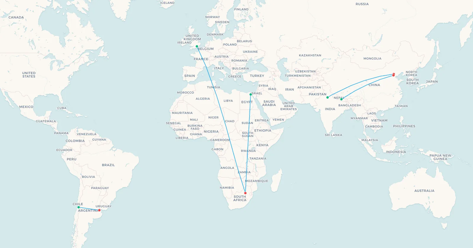
A related problem applies after an engine failure. A twin that loses one engine cannot hold cruise altitude and gradually descends to its drift-down altitude. Where the terrain sits above that altitude, the aircraft has nowhere to go. Add sparse and extremely high-elevation diversion airports, severe mountain wave turbulence and cold enough temperatures to worry about fuel freezing, and the Himalaya becomes a region that most operators route around rather than over. The handful of scheduled services that do cross it, such as Himalaya Airlines between Kathmandu and Beijing Daxing, run with terrain escape procedures written specifically for the corridor.
The same logic on a smaller scale explains why flights between Santiago and Buenos Aires cross the Andes at a chosen low point rather than straight over Aconcagua, all 22,838 feet of it.
Then there is the mundane version of the constraint: you fly on published airways, not on whatever line you like. Continental airspace is a road network of named routes and reporting points, allocated by air traffic control, and where that network is sparse the detours are structural. Africa is the clearest case. Its usable airway structure is far thinner than the continent's size suggests, and long stretches of it have been bent around Libyan and Sudanese airspace, which is why a London to Johannesburg flight follows such a specific north-to-south spine.
➕ Add these 5 routes to my map | 🗺️ Preview these routes on the map | 📥 CSV
Finally, airspace costs money. Almost every country charges an overflight fee for the privilege of crossing it, billed by aircraft weight and distance flown, and the rates vary enormously from one border to the next. It is rarely enough on its own to justify a long detour, but on a marginal routing it is the tiebreaker, and it is the reason two airlines flying the same city pair on the same day can file visibly different flight plans.
So How Much Longer Does All of This Make Your Flight?
Less than you would think on a normal route, and far more than you would think on a constrained one.
- On an unconstrained long-haul route, very little. A flight plan that has to respect winds, tracks and airways typically ends up only a small percentage longer than the pure great circle. The system is good at this.
- Wind is worth more than the detour costs. A track that adds 100 miles to catch 80 mph of extra tailwind is a straightforward win, which is why the optimal path changes from day to day on the same city pair.
- Closed airspace is where the real damage is. One to three hours on Europe to Northeast Asia, four hours added to Helsinki to Tokyo, three hours or more on some India to Central Asia services, and a bill in the hundreds of millions of dollars a year for a single affected airline.
- ETOPS rarely costs anything now. At ETOPS-330 and ETOPS-370 the diversion circles overlap across almost all of the world's water. The rule shaped routes far more in the 1980s than it does today.
- Terrain detours are localised but permanent. The Tibetan Plateau is not going to get lower, and the routes around it have looked much the same for decades.
How to See It for Yourself
All of this is visible from the ground with public tools, if you know what to look at.
- Compare the same route in both directions on consecutive days. The eastbound and westbound tracks on a transatlantic or transpacific pair will not mirror each other, and the gap between them is the jet stream.
- Watch the ground speed, not the airspeed. A tracker showing 650 mph is not telling you the aircraft is fast, it is telling you the air is moving.
- Put the pair on a globe, not a map. Any tool that draws a great circle will show you instantly whether the "detour" is a detour at all. That is exactly what the maps on this page are doing.
- Look at what the route avoids, not what it crosses. A Europe to Asia flight bending south through Turkey is not choosing Turkey, it is avoiding Russia and Iran.
- Check the aircraft type before assuming an ocean routing. A four-engined aircraft and an ETOPS-370 twin have very different legal corridors over the same water.
For any pair of airports, what countries will I fly over puts the great circle on a globe and lists every country under it, and the flight distance calculator gives its length.
Search flights London → SingaporeSearch flights LHR → SINEvery Route in This Guide on One Map
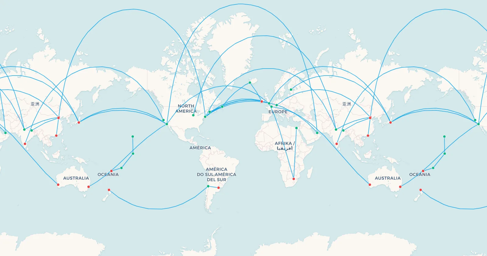
Great circle arcs, ETOPS stepping stones, jet stream pairs, closed-airspace detours and terrain reroutes, all thirty routes plotted together on a single interactive map.
➕ Add these 30 routes to my map | 🗺️ Preview these routes on the map | 📥 CSV
Every CSV on this page uses the same column format the app imports, so you can drop any of them onto your own map and watch the arcs draw themselves. If you would rather plot your real flying instead, our guide to finding your past flight history walks through how to recover it from old emails and loyalty statements.
Frequently Asked Questions
Why don't planes fly in a straight line?
In most cases they do. The shortest path between two points on a sphere is a great circle, which looks curved when it is drawn on a flat map. On top of that geometry, four things bend the real route: wind, the distance rules that apply over open water, closed or restricted airspace, and terrain combined with the published airway network.
What is a great circle route?
The arc formed by slicing a sphere through two points and its centre. It is the genuine shortest path across the Earth's surface, and it is why a flight from Los Angeles to Dubai passes over Greenland rather than crossing Europe.
Why do flights fly over the North Pole?
Because between North America, Europe and Asia the polar route is shorter. Flying near the pole can save hours against an equatorial routing, which is the whole reason transpolar services exist.
Why is the return flight longer than the outbound?
The jet stream. It blows west to east at 100 to 200 mph, so eastbound flights ride it and westbound flights fight it. On a transatlantic pair the difference is commonly an hour or more.
What is ETOPS and does it change the route?
ETOPS limits how far a twin-engined airliner may be from a suitable diversion airport, expressed in single-engine flying time. It shaped ocean routings heavily in the 1980s, but with modern approvals of ETOPS-330 and ETOPS-370 the constraint rarely forces a meaningful detour today.
Why don't planes fly over Tibet or the Himalaya?
A depressurised aircraft has to descend to around 10,000 feet, and the Tibetan Plateau averages above 14,000. Add scarce and very high diversion airports, severe turbulence and drift-down performance after an engine failure, and most operators route around it.
How much longer are flights because of the Russian airspace ban?
Roughly one to three hours on Europe to Northeast Asia routes. Finnair's Helsinki to Tokyo service is the extreme case, going from about nine hours to around thirteen.
What is the fastest transatlantic flight ever?
Concorde, at 2 hours 52 minutes. Among subsonic aircraft, British Airways flight BA112 crossed New York to London in 4 hours 56 minutes on 9 February 2020, reaching 825 mph over the ground inside a jet streak.
Sources
Every figure in this article was checked against a primary source or the original reporting. The main ones, and what each supports:
- The transatlantic speed record: the Flightradar24 account of BA112 and the Guinness World Records entry for the fastest subsonic transatlantic commercial flight.
- ETOPS ratings and diversion airports: The Flying Engineer on what ETOPS actually requires and Simple Flying on the A350's ETOPS-370 approval.
- The Russian airspace ban and its effect on Finnair: The Points Guy on Finnair's Asian network and AeroTime on the EU flight ban extensions.
- The Pakistan airspace closure: the OPSGROUP Pakistan and India airspace update, tracking the closure and its extensions.
- The 2026 Middle East closures: CNN on how the closures reshaped the global route map and the OPSGROUP operational picture on which corridors survived.
- Terrain, drift-down and the Himalaya: Simple Flying on why aircraft avoid the Himalaya and its companion piece on the Tibetan Plateau.
Airspace restrictions, track systems and schedules change constantly, so always confirm current details with the airline or the relevant authority before planning around them.
Every one of these routes is a compromise between the shortest line and the world it has to cross. Your own flights are the same shape, and they are worth seeing drawn properly, on a globe rather than on a rectangle.