231 Countries, 230 Hops, One Line
Take every country and territory on Earth that has an airport. Ask for the shortest possible way to touch all of them in a single continuous chain. What shape comes back?
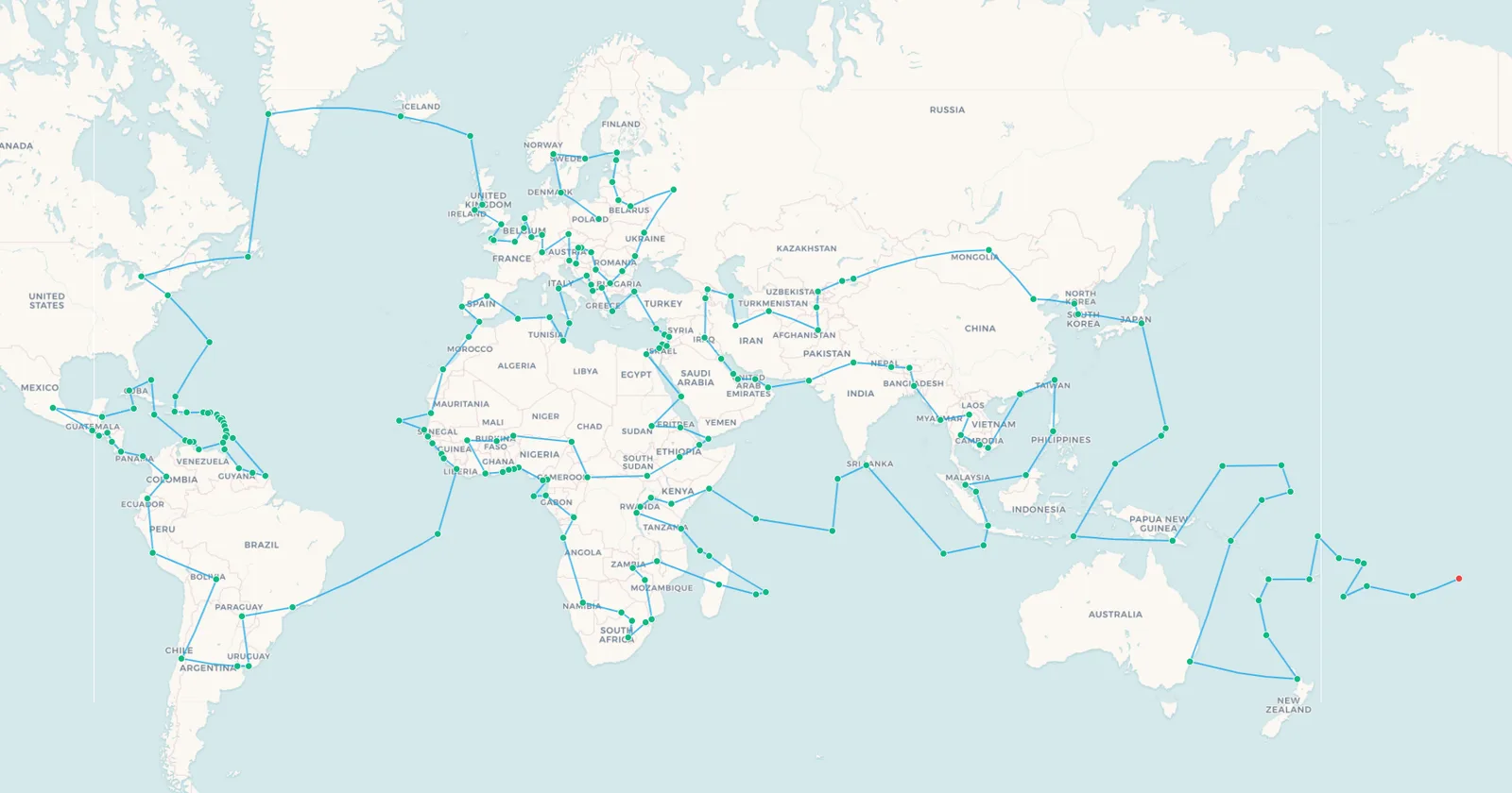
Work it out and the answer is 230 hops covering 155,595 km , or 3.88 laps of the equator . It looks like this.
🗺️ Preview these legs on the map | 📥 Download all 230 legs as CSV
That is the ideal. It is also, in several places, impossible. Some of those 230 lines cannot be flown by anyone, for reasons that have nothing to do with aviation and everything to do with borders, wars and military bases. The gap between the line on the map and the world underneath it is what this article is actually about.
| The route in numbers | Figure |
|---|---|
| Countries and territories with an airport | 231 |
| Hops needed to chain them together | 230 |
| Total distance | 155,595 km , or 3.88 times around the equator |
| Average hop | 676 km |
| Hops under 500 km | 110 of 230, or 48% |
| Hops over 2,000 km | Just 9 |
| Shortest hop | Anguilla to Sint Maarten, 19 km |
| Longest hop | São Paulo to Ascension Island, 3,826 km |
| Countries with no airport at all | 5 |
| Time in the air, plus an hour per turnaround | About 437 hours, roughly 18 days |
Why This Route Cannot Be Flown
Worth being clear straight away, because everything after this depends on it.
This is the shortest the world can be, not a trip you can book . Every line runs between two real airports, one for each country, arranged so the total comes out as small as it possibly can. What none of those lines know is whether an aircraft actually flies them. Many plainly do not, and anyone attempting this for real would connect through hubs and cover a good deal more than 155,595 km.
Which raises the question the rest of this article answers: if this is the shortest the world could be, what is actually stopping you?
The Hops That Do Not Exist
Some of these 230 lines are not merely inconvenient. They cannot be flown at all, by anybody, at any price. They are the most interesting part of the map.
- Tel Aviv to Gaza, and Gaza to Cairo. Yasser Arafat International Airport opened in 1998, closed when the Second Intifada broke out in 2000, and had its control tower bombed and its runway bulldozed by January 2002. Nothing has landed there in a quarter of a century, so Palestine cannot be reached by air at all .
- Seychelles to Diego Garcia, and Diego Garcia to the Maldives. The British Indian Ocean Territory's only runway is a joint US and UK military facility. There are no commercial flights, access is limited to military personnel and contractors on official duty, and there is no ticket you can buy.
- São Paulo to Ascension, and Ascension to Liberia. Ascension Island is served by a UK military airbridge to the Falklands. It is not a commercial destination, and the 3,826 km South Atlantic hop has never been a scheduled route.
- Pyongyang to Seoul, 207 km. One of the shortest hops on the entire route, across the most heavily fortified border on Earth. Air Koryo flies to Beijing, Shenyang and Vladivostok. It does not fly south.
- Brazzaville to Kinshasa, 26 km airport to airport. The two closest capital cities in the world, staring at each other across the Congo River. There is no scheduled flight between them. You take the ferry.
That last one is the whole article in miniature. It is the shortest hop between two capitals anywhere on Earth, and the correct way to make the journey is by boat.
Worth keeping these in proportion, though. They are the absolute barriers, the ones no amount of money or patience gets past, and they are eight hops out of 230. What actually stands between you and this route is far more ordinary: country after country with no war, no closed border and no direct flight, simply because there is not enough traffic between them to fill an aircraft. The destroyed airports are the memorable version of a problem whose usual form is an empty schedule.
The Five Countries With No Airport At All
Before any route can exist, five countries rule themselves out entirely, because they have no airport of any kind.
- Vatican City and Monaco , both too small for a runway. Monaco has a heliport with regular service to Nice, which is as close as flying gets.
- San Marino , surrounded by Italy and served by Rimini, about 25 km away.
- Liechtenstein , between Switzerland and Austria, reached via Zurich.
- Andorra , in the Pyrenees. Andorra-La Seu d'Urgell Airport carries the name but sits in Spain.
Not one of the five has a single airport in the data behind this map. Add Palestine, whose airport exists but is rubble, and the honest count is six countries you cannot fly to . It is also why the count here is countries and territories with an airport , rather than every sovereign state.
Chapter One: Warsaw to Barbados
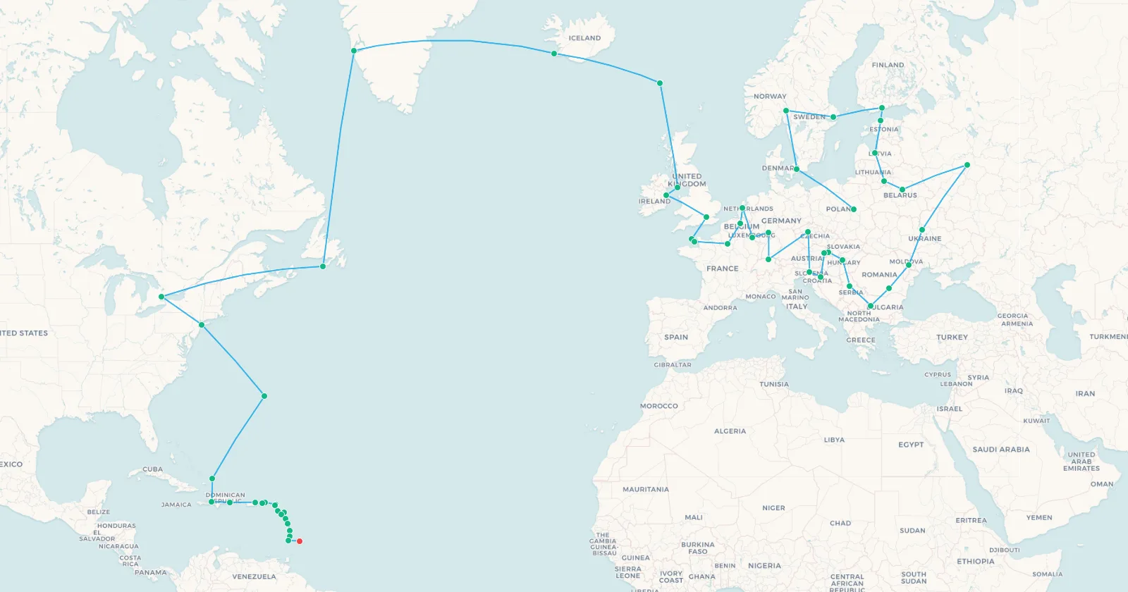
With the impossibilities established, here is the route itself, in five chapters. It begins in Central Europe, works north through Scandinavia and the Baltics, loops back across the continent, then crosses the North Atlantic by the only sensible staircase there is: Faroes, Iceland, Greenland, Saint Pierre and Miquelon, Canada. From there it drops down the eastern seaboard into the Caribbean, where countries arrive so fast the map turns into a scatter of dots.
➕ Add these 55 legs to my map | 🗺️ Preview these legs on the map | 📥 CSV
Search flights Warsaw → Reykjavik Search flights WAW → KEFThis chapter alone covers 56 countries in 22,244 km , the best value anywhere on the route. Europe and the Caribbean are the two places on Earth where borders sit tightest relative to flying distance, and the route exploits both ruthlessly.
It also contains the chapter's own quiet impossibility. Leg 35 asks you to fly Nuuk to Saint Pierre, 1,957 km across the Labrador Sea. Air Saint-Pierre serves Montreal, Halifax and St John's, plus Paris in summer. It does not fly to Greenland, and neither does anyone else. The staircase across the North Atlantic looks tidy on the map and has a missing step in the middle of it.
Chapter Two: Cayenne to Casablanca
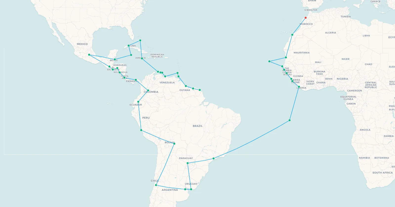
South America is the thinnest stretch of the journey: thirteen countries spread across a continent with long gaps between them. Then comes the single biggest jump on the route, São Paulo to Ascension Island, 3,826 km of empty South Atlantic, before West Africa begins. That particular hop, as we have seen, is a fiction.
➕ Add these 40 legs to my map | 🗺️ Preview these legs on the map | 📥 CSV
Search flights Sao Paulo → Johannesburg Search flights GRU → JNBForty hops, 29,520 km. The contrast with chapter one is stark: roughly the same effort buys a third as many countries.
What makes the Ascension jump stand out is that almost everything around it is real. South America is well connected, and most of these legs correspond to services you could genuinely book. Then the route reaches the coast of Brazil, strikes out into the South Atlantic for the longest hop of the entire journey, and lands on an island reachable only by military airbridge. One leg out, one leg back to Liberia, and neither flight exists. The shortest way across that ocean runs through the only speck of land in it, and the speck turns out to be a Royal Air Force staging post.
Chapter Three: Gibraltar to Diego Garcia
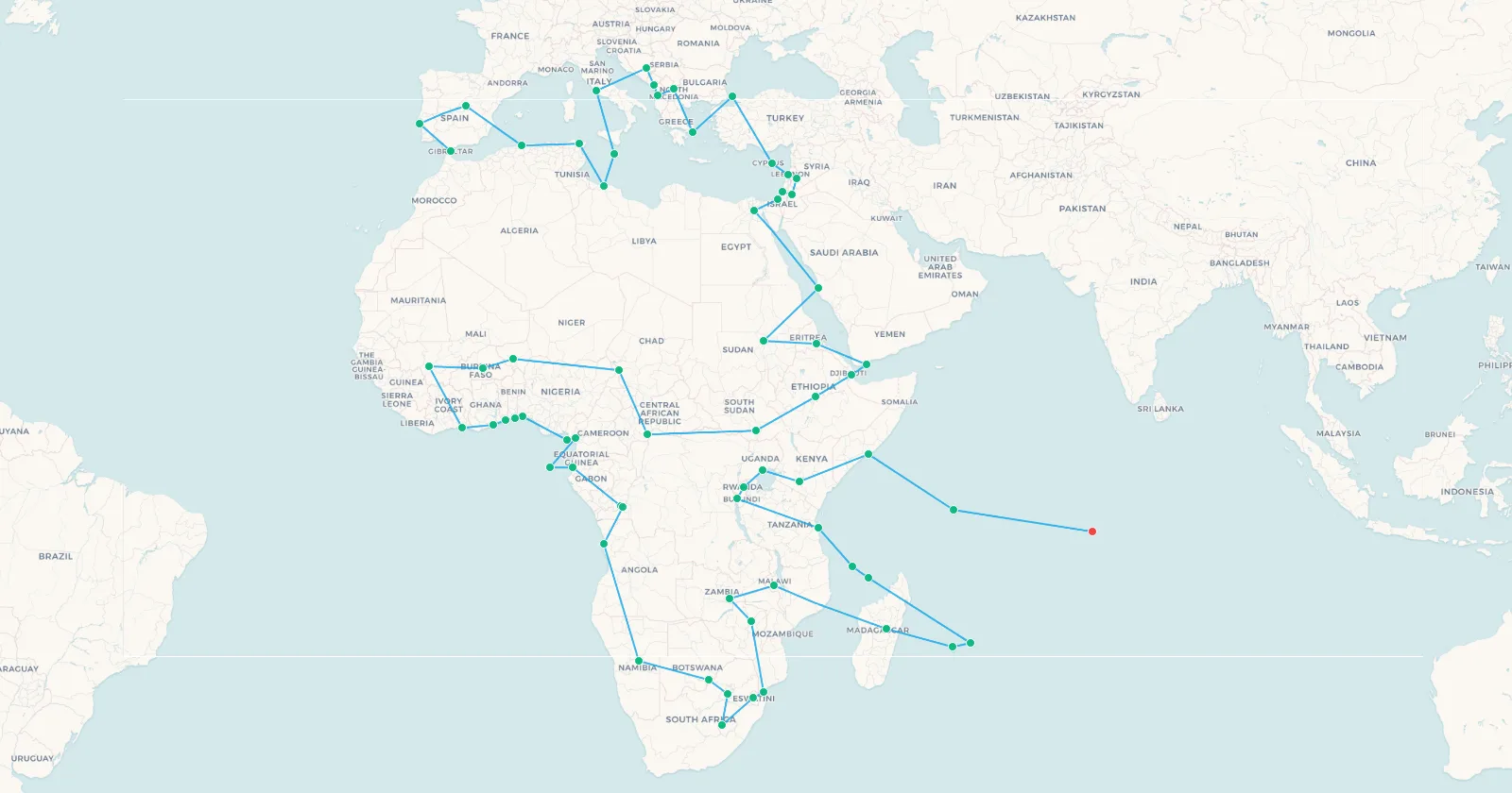
The longest chapter, and the one doing the most work. Sixty-six hops threading the Mediterranean, the Sahel, the Horn of Africa, down through East and Southern Africa, then back up the Indian Ocean islands to a runway no civilian may use. It also crosses and recrosses the line, taking in several of the airports on the equator along the way.
➕ Add these 66 legs to my map | 🗺️ Preview these legs on the map | 📥 CSV
Search flights Casablanca → Nairobi Search flights CMN → NBO67 countries, 40,101 km. Africa is where this trip is won or lost. It holds more countries than any other stretch of the route, and the gaps between them are unforgiving. Several stops appear on our list of the most isolated airports in the world .
Note where the chapter finishes. Having crossed an entire continent, the route heads out into the Indian Ocean and terminates on Diego Garcia , a runway that no civilian aircraft may use. The single most demanding chapter of the journey ends at a place you are not allowed to arrive. The two legs that reach it and leave it are the only way to pick up the British Indian Ocean Territory at all, which is exactly the problem: on a map it is a dot like any other, and in practice it is a closed military base.
Chapter Four: Malé to Tokyo
From the Maldives across South Asia, up through the Gulf and the Caucasus into Central Asia, then east to the Pacific coast. Forty-two hops, 31,782 km, and the densest concentration of closed and restricted airspace anywhere on the route.
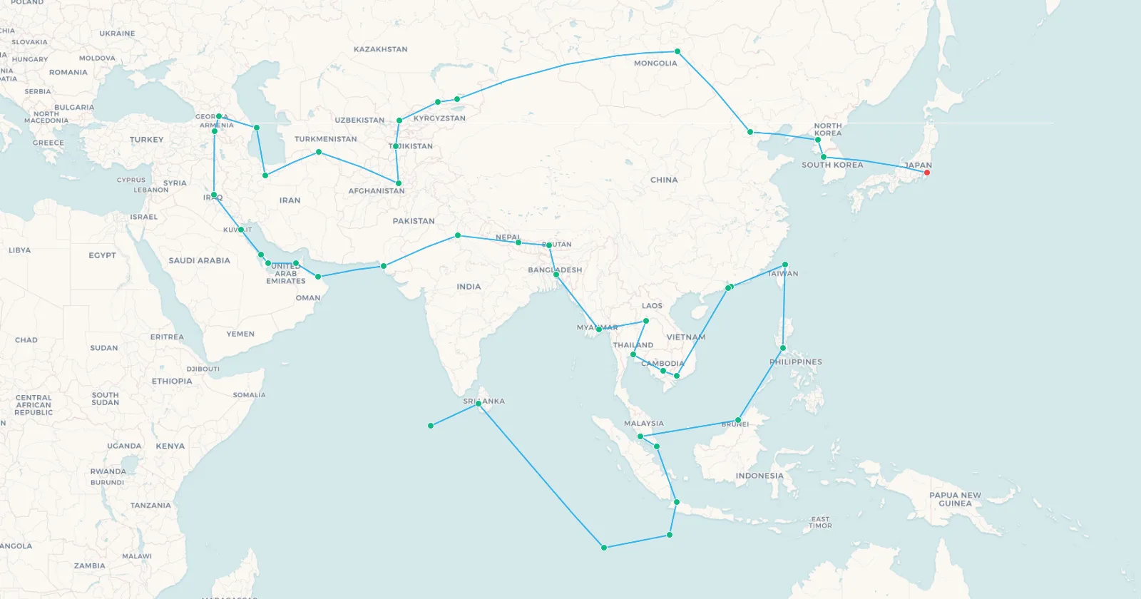
➕ Add these 42 legs to my map | 🗺️ Preview these legs on the map | 📥 CSV
Search flights Dubai → Bangkok Search flights DXB → BKKThis is where geometry and reality diverge hardest, and this chapter carries two of the route's flat impossibilities rather than one.
Leg 185 is Delhi to Karachi, 1,067 km . There has been no scheduled direct service between India and Pakistan since 2019, and the two countries have repeatedly closed their airspace to each other since. On the map it is an unremarkable short hop between two large cities. In practice the shortest legal routing between them runs through a third country. Twenty legs later the route reaches Pyongyang to Seoul , 207 km across a border that has been sealed since 1953.
Neither closure shows up in the distances. That is the trouble with reading the world off a map: it tells you where places are, not whether you are allowed to travel between them. We looked at the same effect in detail in why flights don't fly in a straight line .
Chapter Five: Saipan to Tahiti
The final chapter is the emptiest and, per country, the most expensive. Twenty-three hops and 26,728 km to collect 24 Pacific nations and territories, finishing in French Polynesia.
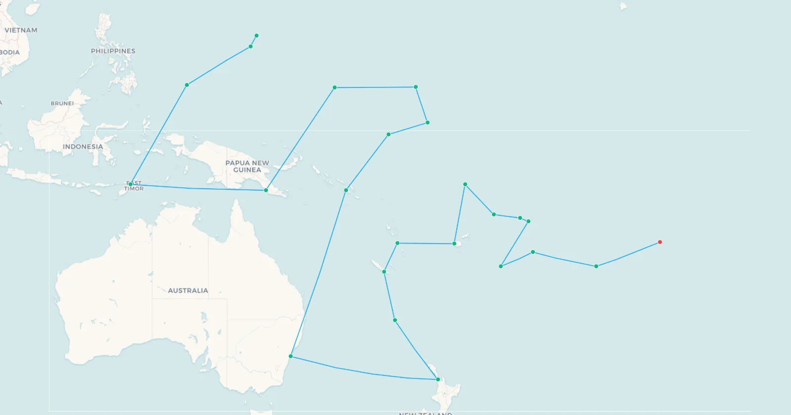
➕ Add these 23 legs to my map | 🗺️ Preview these legs on the map | 📥 CSV
Search flights Nadi → Papeete Search flights NAN → PPTEach Pacific country costs about 1,160 km of flying, against 397 km in chapter one. This is the same geography that produces the region's island hopping networks , and the reason so much of the Pacific is served by multi-stop routings rather than direct flights.
The Pacific fails the traveller for the opposite reason to everywhere else, and it is the most instructive failure on the route. Tarawa to Nauru, Fiji to Funafuti: these legs are real . You can book them. But they run a few times a week, on one carrier, and the next island onward runs on a different few days. Nothing here is closed, destroyed or militarised. The constraint is simply the calendar.
That is what turns a three-week flying time into a months-long trip. Everywhere else on this route the obstacle is a border. In the Pacific it is a timetable, and a timetable is the harder thing to plan around, because waiting four days for the next departure costs you nothing in distance and everything in time. It is the same pattern that shapes the multi-stop airline milk runs that serve remote communities elsewhere in the world.
What the Geometry Tells You
- It is not a long-haul problem. Only nine of 230 hops exceed 2,000 km, and nothing exceeds 3,826. Visiting every country is a very long series of short flights, not a series of epic ones.
- The shortest hops are absurd. Anguilla to Sint Maarten is 19 km. Hong Kong to Macau is 38 km, Jersey to Guernsey 39 km, and the US to British Virgin Islands 47 km. Several of these turn up among the world's shortest international flights .
- Thirty-one countries have exactly one airport. Albania, Brunei, Luxembourg, Barbados, Bahrain, El Salvador and 25 others. These are forced links: the route has no alternative and no room to do better.
- Density beats distance. Chapter one collects a country every 397 km. Chapter five needs 1,160 km per country. How tightly borders are packed matters far more than how far you fly.
For the version people actually book, our guides to round the world tickets and the budget around the world trip deal in real fares and real routings.
Frequently Asked Questions
Can you fly to every country in the world?
No. Five countries have no airport at all: Vatican City, Monaco, San Marino, Liechtenstein and Andorra. Palestine has an
airport but it has been destroyed since 2001. Several other territories on any complete list, including the British Indian
Ocean Territory, have runways closed to civilians.
How many flights would it take to visit every country?
The shortest possible chain is 230 hops, one for each link between the 231 countries and territories that have an airport. A
real trip needs considerably more, because many of those pairs have no direct service and would require connections through a
hub.
How far is it to fly to every country?
The shortest possible chain is 155,595 km, which is 3.88 times around the equator. The average hop is 676 km and nearly half
are under 500 km.
Which countries have no airport?
Vatican City, Monaco, San Marino, Liechtenstein and Andorra. All five are reached overland from a neighbouring country's
airport.
Can you fly from Brazzaville to Kinshasa?
No. They are the two closest capital cities in the world, facing each other across the Congo River with 26 km between their
airports, and there is no scheduled flight between them. The crossing is made by ferry, which runs several times a day and
takes about twenty minutes.
Can you fly to Diego Garcia?
Not as a civilian. The only runway in the British Indian Ocean Territory is a joint US and UK military facility, closed to
commercial traffic.
How long would it take to fly to every country?
About 437 hours in the air allowing an hour per turnaround, which is roughly 18 days of continuous travel. Real attempts take
months or years, because schedules, visas and connections dominate rather than flying time. In the Pacific in particular, the
legs exist but run only a few times a week.
Which part of the world is hardest to cover?
The Pacific, measured by distance per country: about 1,160 km of flying for each one reached, against 397 km in Europe and the
Atlantic. Africa is the largest single block, at 67 countries and 40,101 km.
Sources and Method
Unusually for one of our guides, almost nothing here is quoted from elsewhere. The route, the distances and the country counts all come from the airport data this site runs on, so every figure can be checked against the CSVs on this page.
- The airports are real ones with IATA codes, from the same data behind every map on My Flight Routes. Where a country has more than one, we used its main international airport.
- The distances follow the curve of the Earth, the way a flight path does, rather than a straight line drawn on a flat map.
- The order is the shortest we could find. We kept rearranging the stops until no further change made the total shorter. Calling it the shortest would be overstating it: with 231 stops, checking every possible order is beyond any computer that will ever exist.
- The flights are the one thing we did not look up. No timetable was involved, and nothing here claims a service exists on a given hop. The closures described earlier are documented facts.
The full 230-hop route is above as a CSV download. It is far too long to drop onto a map in one go, which is why the journey is published in five chapters instead, each of which opens or imports with a single click.
The shortest path to every country on Earth is 155,595 km. The reason you cannot fly it has nothing to do with distance, and everything to do with what humans have built, closed, destroyed, and never got round to connecting in the first place.